
As the old adage goes “water is life”, indeed water is indispensable for satisfying basic human needs. Water is important for domestic uses such as drinking, sanitation, washing of clothes, cooking and personal hygiene. Additionally, water is a cross cutting resource used for socio-economic development world-wide and fundamentally the most precious resource for attainment of food security and industrial development. It is for this reason that the United Nations declared access to clean drinking and adequate sanitation a basic human right in 2010. Of course, one wonders why it took so long!!
Zambia’s population has doubled over the last 20 years. The current population is estimated to be 19.5 million. This increase in population has not been met with a corresponding development of water infrastructure to meet the current demand. In the 70s and 80s, most houses had piped water supplied by the local councils or municipality but that is not the case anymore. It is now managed by commercial utilities. The increase in land settlements, gentrification and urbanization has increased the demand for water and most water utility companies have not developed the infrastructure to meet this demand. Most households have had to find an alternative to this problem by accessing groundwater through the drilling of boreholes and shallow wells. Therefore, groundwater has become the alternative to municipal water supply source in most fast-developing towns such as LUSAKA. In a drought year like 2024, ground water resources need to be exploited to mitigate the effects of the drought, particularly because over 85% of the water usage in Zambia is from surface water resources.
The Last Water Resources Master Plan for the in 1995 (Yes over 25 years ago!!) quantified the amount of ground water resources in Zambia to be around 49.6 km3. To put it into context, that is about 1 billion 500 litre-tanks, the same 500-litre tanks that don the streets of Chalala, specifically off Shantumbu Road and other areas that predominantly use groundwater. Therefore, it makes a lot of sense that in the absence of adequate water supply most households seek to explore the use of groundwater. Thus, government bodies like the Water Resources Management Authority (WARMA) seek to promote the utilization of ground water resources but also protect groundwater against pollution and depletion because it is a very reliable source of water supply. Unlike surface water resources, ground water once polluted is very challenging to clean up since it’s static and does not have self-cleansing ability like its counterpart. This also speaks to why drilling companies are regulated to prevent over-exploitation of the ground water which is finite. I could go on and on about sustainable groundwater management but today my main topic is about finding water using various siting methods.
Borehole Siting
Those that have hit a dry borehole before would tell you the anguish that is accompanied by the occurrence. Hit 5 dry boreholes and you instantly feel like selling your plot and breaking the house altogether!! A timely reminder for those wishing to develop your land, ascertain the availability of water before doing any construction on site. This will save you a lot of money and headache. Therefore, it is very important to know where water is likely to be found. This process of identifying the location where water might be found is known as siting. Apart from determining the likely presence of water, siting also involves assessment of the environment to determine suitability of the location. Factors to consider include but not limited to; distance from potential pollution sources, infrastructure, history of water presence and chemical content (Salty or high Iron Content). Siting can be done using both traditional and scientific methods and these will be explained in detailed.
I. Traditional Methods
The most common way of finding water in Zambia and the most widely used method by most drillers is called dowsing. Dowsing involves the use of mostly copper rods to ascertain the location of water. The rods are held into both hands to freely oscillate while traversing the area of interest, where the two free oscillating wires cross indicates the presence of water.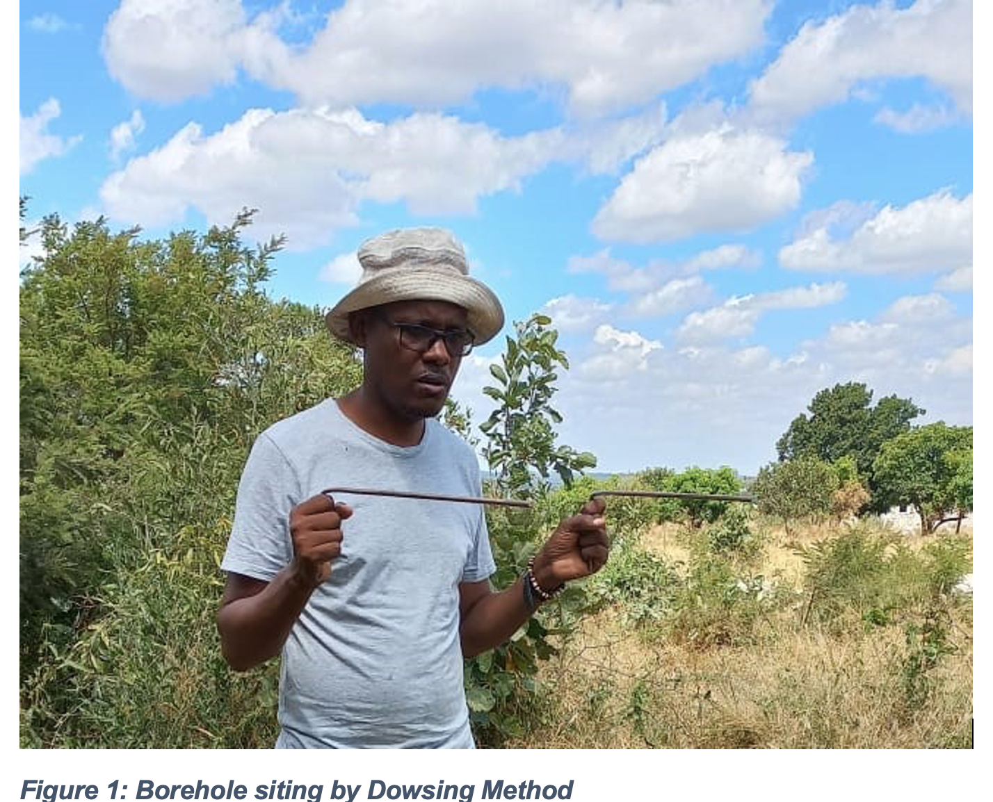
The Technology has been around since the 14th century but the science behind it has not been understood to date. This art has also been reported to have been depicted in 6000-year-old cave paintings in North-Western Africa. In the 1980’s the Germans tested the phenomenon extensively and the results were astounding but it did not offer any insights on why it worked 90% of the time. This method has also been known to work here in Zambia more often times than not. Most reports have attributed this phenomenon to unknown forces; witchery and ancestral spirits especially in Africa. In the US this phenomenon is known as water witching through divination and people who practice the dowsing in the US are known was Water Witches; true Story!!
Another method which is not widely used is the bottle method. An open bottle containing water is put on the palm as the siter traverses the area of interest and where the bottle topples is where the water is likely to be found. This has also been known to work. Although, dowsing is known to work in locating water in both rural and urban areas, the downside is that you cannot determine the depth at which the water is likely to be found. In the old days, our forefathers would simply analyse the trees (Mabuyu tree is a great indicator of water nearby by the way), grass, type of insects and plants and they would instantly tell you where to find water. It is a pity that this indigenous knowledge has not been documented well or passed down generations. These unique methods have since been lost in antiquity. The subjectivity of these methods makes them very unreliable, and this is where modern scientific methods like geophysical surveys come in.
I. Conventional Methods: Geophysical Surveys
The most reliable way of siting for groundwater is by use of conventional methods. These methods often provide more precise and accurate information about subsurface conditions compared to traditional methods like divining rods or dowsing. Not only do they show the precise location but also the depth you are likely to find water which is not possible with traditional methods. Conventional Methods are usually conducted by experts and therefore the chances of success increase incredibly. Furthermore, this is a more cost-effective method as several sites are accessed and ranked according to suitability and probability of success. One thing to note is that ground water siting is not 100% certain, as the saying goes in Bemba “Ichintu chintu umwene” translating to “the proof is in the act of seeing”, similarly ground water is the unseen therefore you cannot determine with 100% certainty as most siters will have you believe with their numerous testimonies. For this article, I will only discuss two common methods: Electromagnetic and Seismic.
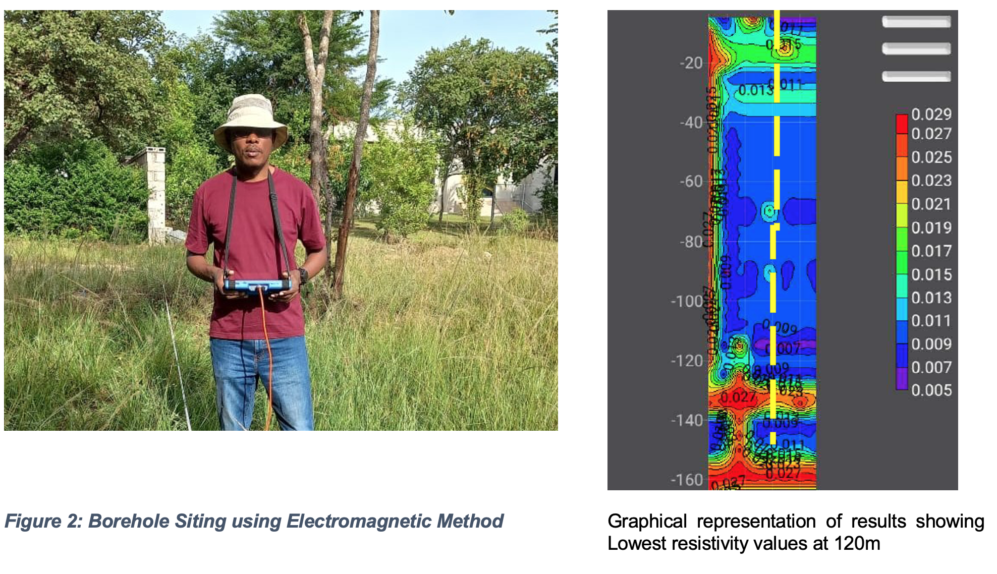
Electromagnetic Method
The electromagnetic method relies on the principle that variations in electrical conductivity of the subsurface materials can indicate the presence of groundwater. In this method, an EM instrument is used to measure the electrical conductivity of the underground. Groundwater, being a good conductor of electricity, typically results in higher conductivity readings compared to dry or low-permeability materials. Conversely, since it is a good conductor of electricity it will show very low resistivity values and other materials that are poor conductors will show high resistivity values.
In this method, EM sensors are deployed on the ground surface and a current passed in the ground to obtain electrical conductivity values at different depths underground. By conducting surveys across an area of interest, hydrogeologists can map out potential groundwater resources and show underground presence of water aquifers or streams.

Seismic Methods
Generally, this method is not common in Zambia, but I have worked with in places where the EM method proved inconclusive. This method involves generating seismic waves at the ground surface using a seismic energy source (anything that can cause a vibration) such as a hammer. These waves travel into the ground and reflect off interfaces between different rock layers (Different materials have different reflective capabilities). The differences in the properties of the ground layers where the wave is introduced will be reflected to the measuring device which shows the results for the different formations underground, which in turn, shows the presence of water.

Advantages of Borehole Siting
Borehole siting, conventional siting that is, has numerous advantages over not siting or use of traditional methods. To most prospective borehole owners, it looks like an unnecessary cost and waste of time but as life has taught us, doing things the right way first time, saves us both money and time. There are a lot of advantages to siting a borehole before you drill one and these are:
Accuracy and Reliability: Siting for a borehole increases your chances of drilling a borehole but it ensures that you have right location and drilling depth before you drill a borehole.
Cost Efficiency: Effective borehole siting can help minimize drilling costs by avoiding unnecessary exploration and unsuccessful boreholes. By selecting sites with high probability of success based on geological, hydrogeological, and geophysical assessments, expenses associated with drilling in unfavourable locations are reduced.
Sustainability: Selection of a site with high yield and faster recharge ability ensures that you have water supply in the long-term without needing to drill another borehole. This is ascertained by conducting a pumping test and analysing the geology of the area.
Pollution Reduction: Siting for a borehole ensures that water is protected from pollution, especially for new construction sites. In knowing the location of the borehole, onsite sanitation services, solid waste facilities and any other pollution source are constructed away from the water sources to minimize chances of contamination.
Water Quality: Siting and subsequent testing of the water informs you on the quality of the water and what it can be used for. This ensures you do not consume water that will be detrimental to your health.
Overall, effective borehole siting plays a crucial role in maximizing the benefits of groundwater resources while minimizing associated risks and impacts. By considering a range of factors including hydrogeology, water quality and environmental considerations community needs, borehole siting can contribute to sustainable utilization of ground water. Finally, for those that have boreholes for water supply it is good practice to increase green spaces in your yard to allow for groundwater recharge. I know paved yard makes your property looks fashionable but from a ground water recharge perspective it shortens that life span of your borehole due to reduced infiltration. The rainwater is converted into surface run-off instead of boosting your ground water storage. Simba grass (Kapinga), crushed stones will always be better than a paved yard for borehole owners.
(The author is Director – Water Resources Management, Water Resources Management Authority. Corresponding email: [email protected])


2 responses
This is very informative and timely especially for us upcoming farmers.
Thanks for sharing such an informative topic..